Friends of Athens has created a walking tour of the most historic buildings in our village. The tour runs in your browser – no need to download a separate app. Please note, this is a street-tour only. Private residences on this tour are not open for interior tours.
Access the Athens Village Tour HERE or tap the image above.
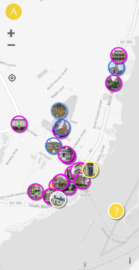
About the App
A village map will act as your tour’s home base. Tap the compass icon to find your location on the map. Tap an icon on the map to see detailed information about each property.
There are five property types described in the tour:
For many properties, you can listen to a spoken word description in your audio player. Tap the triangular “play” icon overlaying the image or at the bottom of the screen to start/stop play.
After viewing a property, return to the map by pressing the left-arrow in the top-left corner of each property page.
This tour application contains descriptive text from Historic Places in Greene County New York (2009) written by, copyrighted by and used with the permission of the Greene County Historical Society and Flint Mine Press. The mobile application itself was built by Dynamic5 with the aid of open source software by Guardian Project. Financial assistance for the application’s development was provided by Gerry Bunting and Maggie Moree. Photography used in the application was provided by David Oliver (@shelteredexistence) and Lynda Shenkman (@kayakerlynda). Please report any problems with, or questions about, this application via our Contact page.
About the Village of Athens
Originally part of the traditional homelands of the Mohicans, an Algonquian people, the land comprising the Village of Athens was colonized by Europeans beginning in 1667 when John Clute, Jurian Tennisse, John Hendrick De Bruyn transacted a deed with five native representatives whose names were given as Sachamoes, Marinate, Keesiewey, Papeuna, and Massehas. This original sale was later consolidated under the ownership of Jan Van Loon, from whose name derives the first name for Athens: Loonenburg.
Loonenburg was originally a sparsely settled agrarian community. Neighboring communities at Claverack, Coxsackie, and Catskill (now the sites of modern Hudson, West Coxsackie, and Leeds) were the closest small centers of population. In 1703 a Lutheran Church was organized at Loonenburg, the community’s first church, and fostered the growth of a small neighborhood in what is now known as the “Upper Village” north of modern Market Street. Much of the wealth of the early community was derived from agricultural pursuits and speculation in valuable lands, and the Van Loons and their neighbors persisted as the principal families of the place until the end of the American Revolution.
In the late 1780s and early 1790s, New England families began moving west in great numbers to take advantage of available land and new business opportunities – it was in this era of rapid transformation that the City of Hudson was founded. Speculators set their sights on Loonenburg soon after, and in 1794 members of the Livingston family purchased land on the north of the village and commissioned a survey for a grand planned community called Esperanza. Their speculation failed to achieve the vision of a neoclassical city, but some businessmen from Hudson led by Isaac Northrup succeeded in purchasing the farms of John Van Loon and his neighbors just to the south upon which they had a village grid surveyed in 1801.
Within four short years a bustling village stood where had once been quiet Loonenburg. The New York State Legislature, on hearing a petition, passed an act to incorporate Isaac Northrup’s community as the new Village of Athens in 1805. It is the results of this that you see today – stately Federal architecture, an efficient street plan, and an orientation facing the river that was the heart of the region’s commerce.
As you walk the Village using this guide, consider that the architecture of the community perfectly encapsulates two centuries of waxing and waning fortunes, fascination with the latest trends, and sensitivity to the rich history of this place. In four square miles stand the ancient homes of Dutch farmers alongside the grand homes of early merchants, immigrant industrialists, and civic spaces devoted to education and governance. Enjoy your walk!